


Introducing our stunning map showcasing the pristine Table Rock Lake, straddling Barry, Stone, and Taney Counties in Missouri as well as Boon and Carroll Counties in Arkansas. Designed by our friends at Lake Art, this unique map sign captures the beauty and intricate details of this idyllic location, allowing you to relive your family's cherished memories on the lake. With its clear blue waters, Table Rock Lake is a popular destination for outdoor enthusiasts. The area is surrounded by stunning natural beauty, including rolling hills, towering bluffs, and verdant forests, making it an ideal spot for hiking, camping, and other recreational activities.
Fun fact: When the Table Rock Dam was constructed, the small village of Oasis was evacuated, and its remains still lie below the surface. Scuba diving is the lake's best-kept secret, and the only way to visit the sunken town of Oasis, adding a unique and fascinating historical element to your visit.
Other Lakes Available: Don’t see your lake here? Not to worry, contact us and inquire about your lake. We have a vast collection of lake signs in queue to be added to the website, so yours may have not been uploaded yet.
Disclaimer: Maps are intended for decoration only, may contain erroneous information, and may not be used for navigation. All geography changes over time. Lake depths not only change over the years, but season-to-season as well. And ocean depths, of course, change with the tides.
Art by Lake Art.
Table Rock Lake, Missouri/Arkansas - Wood & Metal Wall Art


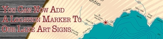
Elevate your décor with our personalized Lake Art maps, an offering that blends cartographic elegance with a personal touch. To make these maps uniquely yours, we offer the option to add a distinctive red location marker, pinpointing a special place that holds significance for you.
Just enter the address or coordinates (in the form of latitude and longitude) when placing your order, and we will take care of the rest, creating a customized piece of art that is both meaningful and aesthetically pleasing.
For a map without a marker, simply leave the personalization field blank.
Secure Payment
Made to Order
Handcrafted in Montana, USA.
© Lake Art. All Rights Reserved.
Introducing our stunning map showcasing the pristine Table Rock Lake, straddling Barry, Stone, and Taney Counties in Missouri as well as Boon and Carroll Counties in Arkansas. Designed by our friends at Lake Art, this unique map sign captures the beauty and intricate details of this idyllic location, allowing you to relive your family's cherished memories on the lake. With its clear blue waters, Table Rock Lake is a popular destination for outdoor enthusiasts. The area is surrounded by stunning natural beauty, including rolling hills, towering bluffs, and verdant forests, making it an ideal spot for hiking, camping, and other recreational activities.
Fun fact: When the Table Rock Dam was constructed, the small village of Oasis was evacuated, and its remains still lie below the surface. Scuba diving is the lake's best-kept secret, and the only way to visit the sunken town of Oasis, adding a unique and fascinating historical element to your visit.
Other Lakes Available: Don’t see your lake here? Not to worry, contact us and inquire about your lake. We have a vast collection of lake signs in queue to be added to the website, so yours may have not been uploaded yet.
Disclaimer: Maps are intended for decoration only, may contain erroneous information, and may not be used for navigation. All geography changes over time. Lake depths not only change over the years, but season-to-season as well. And ocean depths, of course, change with the tides.
Art by Lake Art.